From Wikipedia, the free encyclopedia
Coordinates:  27°00′N 30°00′E / 27, 30
The Geography of Egypt can be split into two general sections. Egypt is located in the northern part of Africa; however, it includes the Sinai Peninsula, which is considered part of Southwest Asia. Therefore, Egypt is located in both North Africa and Southwest Asia.
Egypt has shorelines on the Mediterranean Sea and the Red Sea. It borders Libya to the west, Sudan to the south, and the Gaza Strip and Israel to the east. Egypt, covering 1,001,449 square kilometers of land, is about the same size as Texas and New Mexico combined, four times the size of the UK and double that of France. Its longest distance from north to south is 1,024 kilometers, and from east to west is 1,240 kilometers. Egypt's natural boundaries consist of more than 2,900 kilometers of coastline along the Mediterranean Sea, the Gulf of Suez, the Gulf of Aqaba and the Red Sea.
Governorates
Egypt is divided into twenty-six governorates (sometimes called provinces), which include four city governorates: Alexandria (Al Iskandariyah), Cairo (Al Qahirah), Port Said (Bur Said) and Suez. Also included are the nine governorates of Lower Egypt in the Nile Delta region, the eight governorates of Upper Egypt along the Nile River south from Cairo to Aswan, and the five frontier governorates covering Sinai and the deserts that lie west and east of the Nile.
Natural regions
Egypt is predominantly desert. An area of only 35,000 square kilometers - 3.5 % of the total land area - is cultivated and permanently settled. Most of the country lies within the wide band of desert that stretches from Africa's Atlantic Coast across the continent and into southwest Asia.
Egypt's geological history has produced four major physical regions:
Despite covering only about 5.5% of the total area of Egypt, the Nile Valley and Nile Delta are the most important regions, being the country's only cultivable regions and supporting about 99% of the population. The Nile valley extends approximately 800 km from Aswan to the outskirts of Cairo. The Nile Valley is also known as Upper Egypt, while the Nile Delta region is known as Lower Egypt. Steep rocky cliffs rise along the banks of the Nile in some stretches, while other areas along the Nile are flat, with space for agricultural production. In the past, flooding of the Nile during the summer provided silt and water to make agriculture possible on land that is otherwise very dry. Since construction of the Aswan Dam, agriculture in the Nile valley depends on irrigation. The Nile delta consists of low, flat-lying areas. Some parts of the delta are marshy and water-logged, and thus not suitable for agriculture. Other areas of the delta are used for agriculture.[1]
Nile Valley and Delta

Nile delta, and the entire course of the Nile
The Nile Valley and Delta, the most extensive oasis on earth, was created by the world's longest river and its seemingly inexhaustible sources. Without the topographic channel that permits the Nile to flow across the Sahara, Egypt would be entirely desert. The Nile River traverses about 1,600 kilometers through Egypt and flows northward from the Egyptian-Sudanese border to the Mediterranean Sea. The Nile is a combination of three long rivers whose sources are in central Africa: the White Nile, the Blue Nile, and the Atbarah.
The White Nile, which begins at Lake Victoria in Uganda, supplies about 28% of the Nile's waters in Egypt. In its course from Lake Victoria to Juba in southern Sudan, the elevation of the White Nile's channel drops more than 600 meters. In its 1,600-kilometer course from Juba to Khartoum, Sudan's capital, the river descends only 75 meters. In southern and central Sudan, the White Nile passes through a wide, flat plain covered with swamp vegetation and slows almost to stagnation.
The Blue Nile, which originates at Lake Tana in Ethiopia, provides an average of 58% of the Nile's waters in Egypt. It has a steeper gradient and flows more swiftly than the White Nile, which it joins at Khartoum. Unlike the White Nile, the Blue Nile carries a considerable amount of sediment. For several kilometers north of Khartoum, water closer to the eastern bank of the river is visibly muddy and comes from the Blue Nile, while the water closer to the western bank is clearer and comes from the White Nile.
The much shorter Atbarah River, which also originates in Ethiopia, joins the main Nile north of Khartoum between the fifth and sixth cataracts (areas of steep rapids) and provides about 14% of the Nile's waters in Egypt. During the low-water season, which runs from January to June, the Atbarah shrinks to a number of pools. But, in late-summer, when torrential rains fall on the Ethiopian plateau, the Atbarah provides 22% of the Nile's flow.
The Blue Nile has a similar pattern. It contributes 17% of the Nile's waters in the low-water season and 68% during the high-water season. In contrast, the White Nile provides only 10% of the Nile's waters during the high-water season but contributes more than 80% during the low-water period. Thus, before the Aswan High Dam was completed in 1971, the White Nile watered the Egyptian stretch of the river throughout the year, whereas the Blue Nile, carrying seasonal rain from Ethiopia, caused the Nile to overflow its banks and deposit a layer of fertile mud over adjacent fields. The great flood of the main Nile usually occurred in Egypt during August, September, and October, but it sometimes began as early as June at Aswan and often did not completely wane until January.
The Nile enters Egypt a few kilometers north of Wadi Halfa, a Sudanese town that was completely rebuilt on high ground when its original site was submerged in the reservoir created by the Aswan High Dam. As a result of the dam's construction, the Nile actually begins its flow into Egypt as Lake Nasser, which extends south from the dam 320 kilometers to the border and an additional 158 kilometers into Sudan. Lake Nasser's waters fill the area through Lower Nubia (Upper Egypt and northern Sudan) within the narrow gorge between the cliffs of sandstone and granite created by the flow of the river over many centuries. Below Aswan the cultivated floodplain strip widens to as much as twenty kilometers. North of Isna (160 kilometers north of Aswan), the plateau on both sides of the valley rises as high as 550 meters above sea level; at Qina (about 90 kilometers north of Isna) the 300-meter limestone cliffs force the Nile to change course to the southwest for about 60 kilometers before turning northwest for about 160 kilometers to Asyut. Northward from Asyut, the escarpments on both sides diminish, and the valley widens to a maximum of twenty-two kilometers. The Nile reaches the Delta at Cairo.
At Cairo, the Nile spreads out over what was once a broad estuary that has been filled by silt deposits to form a fertile, fan-shape delta about 250 kilometers wide at the seaward base and about 160 kilometers from north to south. The Nile Delta extends over approximately 22,000 square kilometers (roughly equivalent in area to Massachusetts). According to historical accounts from the first century A.D., seven branches of the Nile once ran through the Delta. According to later accounts, the Nile had only six branches by around the twelfth century. Since then, nature and man have closed all but two main outlets: the east branch, Damietta (also seen as Dumyat; 240 kilometers long), and the west branch, Rosetta (235 kilometers long). Both outlets are named after the ports located at their mouths. A network of drainage and irrigation canals supplements these remaining outlets. In the north near the coast, the Delta embraces a series of salt marshes and lakes. The most notable among them are Idku, Al Burullus, and Manzilah.
The fertility and productivity of the land adjacent to the Nile depends largely on the silt deposited by floodwaters. Archaeological research indicates that people once lived at a much higher elevation along the river than they do today, probably because the river was higher or the floods more severe. The timing and the amount of annual flow were always unpredictable. Measurements of annual flows as low as 1.2 billion cubic meters and as high as 4.25 billion cubic meters have been recorded. For centuries Egyptians attempted to predict and take advantage of the flows and moderate the severity of floods.
The construction of dams on the Nile, particularly the Aswan High Dam, transformed the mighty river into a large and predictable irrigation ditch. Lake Nasser, the world's largest artificial lake, has enabled planned use of the Nile regardless of the amount of rainfall in Central Africa and East Africa. The dams have also affected the Nile Valley's fertility, which was dependent for centuries not only on the water brought to the arable land but also on the materials left by the water. Researchers have estimated that beneficial silt deposits in the valley began about 10,000 years ago. The average annual deposit of arable soil through the course of the river valley was about nine meters. Analysis of the flow revealed that 10.7 million tons of solid matter passed Cairo each year. Today the Aswan High Dam obstructs most of this sediment, which is now retained in Lake Nasser. The reduction in annual silt deposits has contributed to rising water tables and increasing soil salinity in the Delta, the erosion of the river's banks in Upper Egypt, and the erosion of the alluvial fan along the shore of the Mediterranean Sea.
Western Desert
The Western Desert covers about 700,000 square kilometers (equivalent in size to Texas) and accounts for about two-thirds of Egypt's land area. This immense desert to the west of the Nile spans the area from the Mediterranean Sea south to the Sudanese border. The desert's Jilf al Kabir Plateau has an altitude of about 1,000 meters, an exception to the uninterrupted territory of basement rocks covered by layers of horizontally bedded sediments forming a massive plain or low plateau. The Great Sand Sea lies within the desert's plain and extends from the Siwa Oasis to Jilf al Kabir. Escarpments (ridges) and deep depressions (basins) exist in several parts of the Western Desert, and no rivers or streams drain into or out of the area.
The government has considered the Western Desert a frontier region and has divided it into two governorates at about the twenty-eighth parallel: Matruh to the north and New Valley (Al Wadi al Jadid) to the south. There are seven important depressions in the Western Desert, and all are considered oases except the largest, Qattara, the water of which is salty. The Qattara Depression is approximately 15,000 square kilometers (about the size of Connecticut and Rhode Island) and is largely below sea level (its lowest point is 133 meters below sea level). Badlands, salt marshes, and salt lakes cover the sparsely inhabited Qattara Depression.
Limited agricultural production, the presence of some natural resources, and permanent settlements are found in the other six depressions, all of which have fresh water provided by the Nile or by local groundwater. The Siwah Oasis, close to the Libyan border and west of Qattara, is isolated from the rest of Egypt but has sustained life since ancient times. The Siwa's cliff-hung Temple of Amun was renowned for its oracles for more than 1,000 years. Herodotus and Alexander the Great were among the many illustrious people who visited the temple in the pre-Christian era.
The other major oases form a topographic chain of basins extending from the Faiyum Oasis (sometimes called the Fayyum Depression) which lies sixty kilometers southwest of Cairo, south to the Bahariya, Farafirah, and Dakhilah oases before reaching the country's largest oasis, Kharijah. A brackish lake, Birket Qarun, at the northern reaches of Al Fayyum Oasis, drained into the Nile in ancient times. For centuries sweetwater artesian wells in the Fayyum Oasis have permitted extensive cultivation in an irrigated area that extends over 1,800 square kilometers (694 square miles).
Eastern Desert
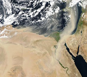
A large plume of Saharan Desert dust (light brownish pixels) were blowing over Libya and Egypt northward over the Mediterranean Sea toward the Middle East, on February 2, 2003.
The topographic features of the region east of the Nile are very different from those of the Western Desert. The relatively mountainous Eastern Desert rises abruptly from the Nile and extends over an area of approximately 220,000 square kilometers (roughly equivalent in size to Utah). The upward-sloping plateau of sand gives way within 100 kilometers to arid, defoliated, rocky hills running north and south between the Sudan border and the Delta. The hills reach elevations of more than 1,900 meters. The region's most prominent feature is the easterly chain of rugged mountains, the Red Sea Hills, which extend from the Nile Valley eastward to the Gulf of Suez and the Red Sea. This elevated region has a natural drainage pattern that rarely functions because of insufficient rainfall. It also has a complex of irregular, sharply cut wadis that extend westward toward the Nile.
The Eastern Desert is generally isolated from the rest of the country. There is no oasis cultivation in the region because of the difficulty in sustaining any form of agriculture. Except for a few villages on the Red Sea coast, there are no permanent settlements. The importance of the Eastern Desert lies in its natural resources, especially oil. A single governorate, the capital of which is at Al Ghardaqah, administers the entire region.
[edit] Sinai Peninsula
This triangular area covers about 61,100 square kilometers (slightly smaller than West Virginia, USA). Similar to the desert, the peninsula contains mountains in its southern sector that are a geological extension of the Red Sea Hills, the low range along the Red Sea coast that includes Mount Catherine (Jabal Katrinah), the country's highest point--2,642 meters. The Red Sea may have been named after these mountains, which are red.
The southern side of the peninsula has a sharp escarpment that subsides after a narrow coastal shelf that slopes into the Red Sea and the Gulf of Aqaba. The elevation of Sinai's southern rim is about 1,000 meters. Moving northward, the elevation of this limestone plateau decreases. The northern third of Sinai is a flat, sandy coastal plain, which extends from the Suez Canal into the Gaza Strip and Israel.
Before the Israeli military occupied Sinai during the June 1967 War (Arab-Israeli war, also known as the Six-Day War), a single Egyptian governorate administered the whole peninsula. By 1982 after all of Sinai was returned to Egypt, the central government divided the peninsula into two governorates. North Sinai has its capital at Al Arish and the South Sinai has its capital in At Tur.
Urban and rural areas
The 1996 census counted 57 percent of Egypt's population as rural, including those residing in agricultural areas in the Nile Valley and Delta, as well as the much smaller number of persons living in desert areas. Rural areas differ from the urban in terms of poverty, fertility rates, and other social factors. Agriculture is a key component of the economy in rural areas, though some people are employed in the tourist industry or other non-farm occupations. In 1992, the percentage of Egypt's population employed in agriculture was 33 percent. The agricultural industry is dependent on irrigation from the Nile River.[2]


 The 'black land' was the fertile land on the banks of the Nile. The ancient Egyptians used this land for growing their crops. This was the only land in ancient Egypt that could be farmed because a layer of rich, black
  The 'red land' was the